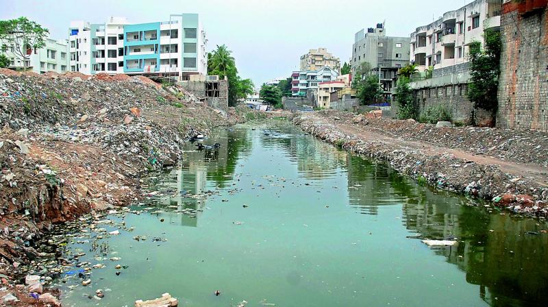
Drainage shortage cripples Hyderabad

Hyderabad: Hyderabad’s integrated urban flood management system is among the worst one can find. With a road network of around 9,000 km, it has only 390 km of stormwater drains. This means more than 80 per cent of the twin cities area has no channel for rain water to drain off.
The existing stormwater drain (SWD) system is capable of handling rainfall of up to just 20 mm per hour. Since 2008, no new SWDs have been constructed even after 12 outlying municipalities were merged with the Municipal Corporation of Hyderabad (MCH).
The SWDs constructed by the gram panchayat in these municipalities have been turned into sewerage channels, due to absence of sewer network. In the peripheral belts of Kapra, Qutbullapur, Kukatpally, Uppal, and LB Nagar, clusters of new property-tax paying colonies have sprung up, that face a flood-like situation due to no storm water drain system.
After the floods of 2000, the MCH as it then was, appointed Kirloskar Consultants to draw up a comprehensive SWD master plan. The report submitted by the consultants proposed widening of 71 nalas.
However, after the formation of the Greater Hyderabad Municipal Corporation (GHMC), another consultant, Voyants Consultants, was appointed to inspect and propose SWD master plan for the entire GHMC area, their suggestion was clearance of bottlenecks such as, preventing garbage from accumulating in nalas and widening of 390 km of nalas.
The municipal corporation needed around Rs 1,200 crore for re-modelling the SDWs, but the entire amount never materialised and so just 54 km of SWDs was re-modelled and no new SWDs were constructed.
GHMC Municipal Commissioner Dr B. Janardhan Reddy gives a detailed explanation for the causes of flooding, but has nothing to say about why the various recommendations made over the years were not carried out.
“Flooding in various localities was found to be because of the many diversions and approximately 900 bends in nalas, which came up due to urbanisation, change of land use, and construction activities. Over the decades, builders ended up changing the earlier natural course, which needs to be restricted by making firmer laws,” he said.
He added that there was no allocation of funds to construct new SWDs. To solve the flooding problem in the most vulnerable areas of the city, the GHMC has now planned 43 works, costing Rs 2,300 crore, aimed at widening nalas for about 100 km, he said. “And in a step aimed at immediate relief, 47 works worth Rs 230 crore on bottleneck stretches in extremely vulnerable flooding areas has also been taken up,” he added.
- 16 storm water zones spread over the city
- Storm water drains in city
- Zone XII, (kukatpally), Zone XIII (Alwal) and Begumpet are areas prone to major flooding
Concern of storm water drains
- Increased impervious areas in the city have led to increased run off and reduced groundwater recharge.
- Irrespective of the natural drainage pattern, infrastructure development has been on the rise.
- Land use planning and permissions not in tune with natural drainage patterns.
- Rampant illegal encroachment on lakes.
- In most countries, stormwater drains are connected with sewage drains. Dirty water is treated before it flows into lakes and rivers.
- In India, though in principal stormwater drains and sewage lines are separated, but water from both drains mixes and is not treated.
- The existing drainage system, covers only 30% of the city and is designed for rainfall of 12 mm/hr. The average rainfall is 23mm/hr and when it peaks it is 52 mm/hr.
- In addition to the inadequate system, residents, commercial establishments and institutions use SWDs to dispose of solid waste. In fact, 25% to 30% of sewage is drained into SWDs.
- Regular maintenance of de-silting and de-clogging of SWDs is not effectively undertaken.
Clogging chaos
- Reduction in groundwater recharge.
- Disappearance of lakes and nalas in the city, which were part of an existing sustainable stormwater management system.
- Clogging of drains due to solid waste
- Untreated stormwater and sewage water being drained into Musi river, Hussainsagar and other lakes has led to high pollution levels of not only water bodies but also groundwater, leading to dangerous health hazards.
- After the floods of 2000, the MCH as it then was, appointed Kirloskar Consultants to draw up a comprehensive SWD master plan. The report submitted by the consultants proposed widening of 71 nalas.
Localities with SWDs
Zone XII
Quthbullapur, Kukatpally, parts of Jubilee Hills, Banjara Hills, Erramanzil, Panjagutta, Ameerpet, Somajiguda, Begumpet, Yousufguda, Sanathnagar, Erragadda, Balanagar. (Ultimate disposal – Hussainsagar diverted to Musi )
Zone XIII
Secunderabad core area, Cantonment, Alwal, Airport area , Marredpally, Rezimental Bazaar, Kavadiguda, Narayanguda, Musheerabad, Himayatnagar, RTC Crossroads, Barkatpura, Adikmet, Amberpet and Premnagar. (Ultimate disposal – Hussainsagar diverted to Musi)
Zone VIII
Nanakramguda, Khajaguda, Toli chowki, Nananagar, Gudimalkapur, Langar Houz, Medhipatnam, Masab Tank, Karwan, Jiyaguda, Manghalghat, Begum Bazaar, Khairatabad, Chinthal Basti. (Ultimate disposal: Hussainsagar diverted to Musi )
Zone V
Old City, Chanderghat, Santhoshnagar, Moosarambagh, Dilshukhnagar, Saroornagar, Chaitanyapuri. (Ultimate disposal – Musi )
Zone XV
Malkajgiri, Uppal, Osmania University, Patelnagar, Ramanthapur. (Ultimate disposal – Musi )
Zone XI
Hafizpet, Miyapur, Madinaguda, Gangaram. (Ultimate disposal – Nakka Vagu /Manjeera)
Zone X
Ramachandrapuram, Patancheruvu, Hyderabad Central University, Kondapur, Lingampally. (Ultimate disposal – Nakka Vagu /Manjeera )

