Drone Tech Aids Ankola Landslide Search, 4 Contact Points Identified
Mangaluru: In response to a requisition by the Deputy Commissioner of Karwar on July 23, 2024, the Drone-based Intelligent Buried Object Detection System (DIBODS) from QuickPay Pvt Ltd, developed by Inworks Technologies, was deployed for a search and detection operation at the landslide site in the Shiruru area.
The operation commenced on July 25 at 12.30 pm, following preliminary reconnaissance and planning that began on July 24.
According to a press statement, the report incorporates insights from MLA Satish Krishna Sail, SP Karwar Narayana, an army team led by Maj Abhishekh Kashyap of MLI Center and Hav Suvankar Das of CME Pune, a navy team led by Lt Cdr Shaswat Singh, NDRF team member Shri Arun Dwivedi, SDRF teams, and data from other agencies.
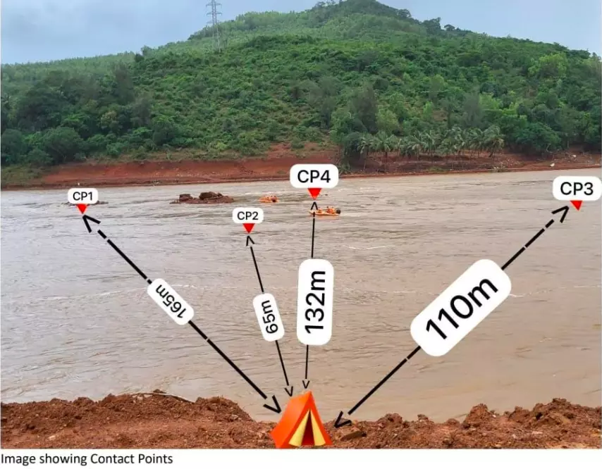
Following numerous DIBODS search and detection runs over two days, confirmation runs through Boat based IBODS, sonar, thermal imager, magnet lines, and interpretation of the DIBODS data, four Contact Points (CP) have been identified. CP4 exhibits signatures closest to a truck’s form and factor.
According to the statement, Contact Point 4 (CP 4)exhibits signatures closest to a truck’s form and factor. The object is likely embedded in a slant formation with earth and rock deposit and cabin likely upwards with a high probability of partial damage. The presence of human form could not be ascertained with surety due to dielectric data bank constraints. Thermal Imagery did not reveal the presence of warm objects. This does not mean the absence of human form.
"CP3, CP2, and CP1 have lesser probability in that order. Relevant information on these has been included. Other relevant information and geo coordinates have been provided in the report for use by concerned agencies involved in recovery operations," the statement added.
Heavy current exceeding 7 knots, muddy water exceeding 30,000 ppm and Orange alert weather conditions, limited preparatory time, were serious constraints and high challenges for the BIPOS team.
Underwater photography and the use of illumination were severely diffused due to the high level of turbidity.
"Limited data bank on reflected underground and underwater wave signals and dielectric differentiation patterns are also a constraint presently. These were partially overcome by the human interface," the statement added.


